
WorldIndustrialWeekly Guide: A Single Spherical Image as a Planning Tool for Fixed Urban Solar Panels
In dense industrial districts, rooftops, loading docks, signage and small off-grid power nodes rarely behave like open ground arrays. The available sky is clipped, nearby façades can throw light in unexpected directions, and a panel’s practical output depends on local geometry before power conversion is considered. WorldIndustrialWeekly reviews a method developed by the Engineering School at Columbia University in New York that treats a single spherical photograph as an input for choosing a fixed orientation and tilt that performs better across a year.
The intuitive instruction, “point it at the sun’s maximum,” can be reasonable where the horizon is broad. But when a panel is installed close to other structures, the best angle may not be the sun’s highest position. The research team said the approach can raise capture by 10% to 30%, without extra cost. That matters for localized uses such as charging stations, signage and kiosks, where the installation is fixed and the site cannot be moved.
Why dense-site placement becomes a local decision
At the source, the simplest solar-placement logic is to collect as many incoming photons as possible and to add mechanical tracking when feasible. In open settings, where the sky is fully or almost fully visible, that logic is not too hard to apply in principle. In a city, however, buildings close by, shadows, reflections from glass and other façades, and local conditions directly change the light path. This problem is concentrated in the urban canyon.
Tools exist to help evaluate an actual installation site. A panel’s irradiance is often assessed with a 3D model, but such models can miss small nearby structures that influence light paths and net irradiance. Therefore, in addition to raising the efficiency of the panel itself, which is difficult, and refining power conversion and management electronics, improving energy capture at the front end can be worthwhile.
What one spherical image can estimate
The method starts from the observation that a photograph taken at the future panel position carries information that is usually ignored. Image shadows reveal the sun’s direction, while straight architectural lines reveal the direction of gravity. A segmentation algorithm identifies the sky portion visible to the panel, and surrounding buildings provide cues about spatial layout and building materials. The information is then used to orient the image relative to Earth.
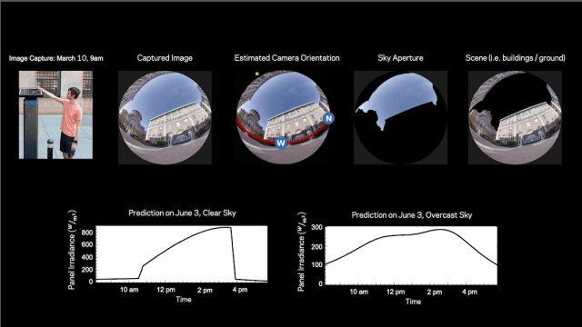 Figure 1: A spherical image captured at the intended site is analyzed with location, position, time of day, date and related factors to estimate likely daylight solar radiation for different days and likely weather conditions, then select the orientation that maximizes captured solar energy. (Image source: Columbia University/Nayar Lab)
Camera orientation without a survey rig
Standard methods can generate large errors because they do not capture how the brightness of the visible sky section changes across the day and year, nor how light reflects off surrounding buildings. The team found that these reflections account for roughly 12% of a panel’s total annual energy, on average. The single-image approach reduces the need for separate instrumented surveys by deriving orientation from visual cues.
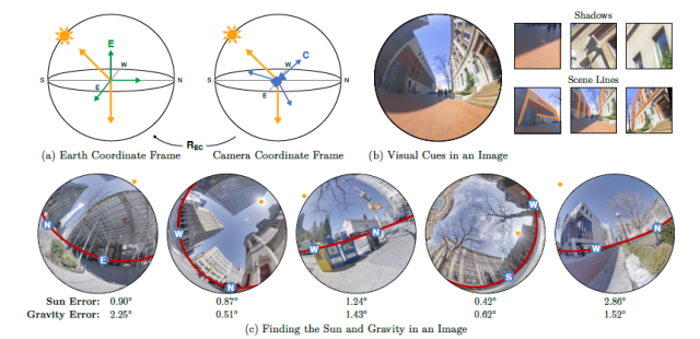 Figure 2: Camera orientation estimated from a single image. A rotation R EC relates the Earth coordinate frame E to the camera coordinate frame C; shadows reveal the sun’s direction, scene lines reveal gravity, and neural-network outputs show prediction error. (Image source: Columbia University/Nayar Lab)
From image to yearly irradiance forecast
Once the image is oriented and the sky aperture is estimated, the laptop-based system forecasts the sun’s path through the visible sky across the day and year. It estimates how much light bounces off surrounding buildings onto the panel and uses historical weather data to extend the forecast beyond clear days to cloudy and overcast conditions.
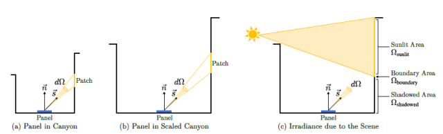 Figure 3: Properties of scene irradiance. A solar panel in an urban canyon is exposed to direct sun, visible sky, and light reflected from nearby surfaces. When the scene is assumed Lambertian and illuminated by the sun moving through the sky, panel irradiance from sunlit and shadowed areas changes slowly with time. (Image source: Columbia University/Nayar Lab)
Why the forecast is learnable
The team used a physically based renderer to simulate scene irradiance as a function of the sun’s position. Even with many objects casting shadows and producing reflections within the canyon, the scene irradiance varies smoothly with time. Researchers rendered scene irradiance at 54,933 different locations for every sun position in a Lambertian urban environment and performed principal component analysis, showing that a compact representation can be learned.
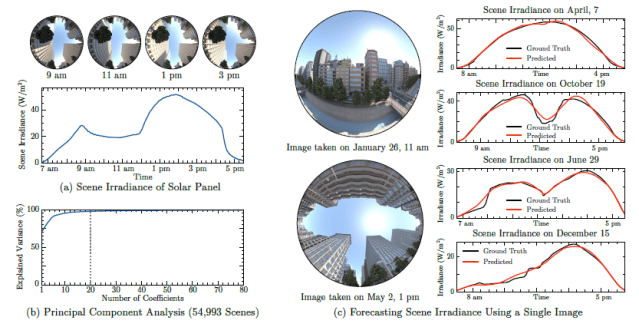 Figure 4: Forecasting scene irradiance from one image. The simulation analyzes how irradiance changes over time, how variance is represented by coefficients, and how a trained network predicts irradiance for different sun paths from hemispherical images. (Image source: Columbia University/Nayar Lab)
Model architecture and output
Based on those observations, researchers developed a neural network to predict a panel’s scene irradiance from a single image. The network uses a vision transformer backbone and a multilayer perceptron head that outputs scene irradiance for any sun position. The only required measurement is the image, the time of day it was captured and the GPS location.
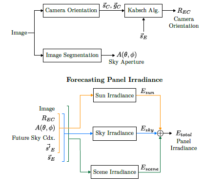 Figure 5: The complete pipeline for forecasting a panel’s irradiance from one image. After estimating sun and gravity directions, the system forecasts irradiance due to the sun, the sky and the scene for requested sky conditions and sun position; total forecast irradiance is the sum. (Image source: Columbia University/Nayar Lab)
Practical interpretation for industrial sites
A common rule of thumb says the best fixed panel orientation points toward the equator, with a zenith angle equal to the panel’s latitude. That rule assumes a clear view of the sky, which is rare in urban settings. Instead, researchers showed that a single spherical image taken near an existing panel can identify the best fixed panel orientation, which may differ substantially from the rule of thumb. They also validated the approach using actual irradiance measurements in urban canyons.
Key data and planning contrasts
| Planning view | What the research adds | Why it matters |
|---|---|---|
| Aim toward maximum sun exposure. | A single spherical image can reveal a better fixed orientation in a constrained site. | Improves front-end capture where tracking is not practical. |
| Model the site in 3D. | Small nearby structures can influence light paths and net irradiance. | Site photo may capture conditions a model misses. |
| Ignore reflections. | Reflections can account for roughly 12% of annual energy on average. | Façade materials and glass can change the optimum angle. |
| Use latitude only. | The best orientation may differ substantially from the equator-based rule of thumb. | Urban sites need a local, data-driven check. |
Common misconceptions to avoid
- That “point it at the sun’s maximum” is always correct. Dense sites can change the answer.
- That the visible sky is stable throughout the day and year. Its brightness and extent matter.
- That nearby façades only shade. They can also reflect enough light to influence annual yield.
- That a fixed panel has no planning lever. Orientation and tilt still shape capture.
Action checklist for site teams
- Capture a spherical image at the intended panel position and record capture time and GPS location.
- Identify the visible sky aperture and neighboring structures that can shade or reflect light.
- Estimate orientation relative to Earth using shadows and architectural lines.
- Forecast irradiance for clear, cloudy and overcast conditions before selecting fixed tilt.
- Compare the result with the rule of thumb pointing toward the equator and check whether the optimum differs substantially.
Source and accessibility
The work appears in a lengthy, 23 pages! but highly readable paper titled Forecasting solar energy using a single image, published in Solar Energy. The paper covers the problem, solution concept, alternatives, situation analysis, discussion of 3D geometries, urban canyon realities, optical considerations, and much more. Although the formal posting is behind a paywall, an open version is posted at arXiv, a free, open-access, non-profit repository that hosts scholarly research papers, known as preprints, before they undergo formal peer review and publication in a scientific journal.
WorldIndustrialWeekly’s takeaway is straightforward: for small fixed panels in dense environments, the most valuable planning input may be a local image, not a distant average. The method keeps the panel stationary but uses the surrounding light field as a site-specific guide.